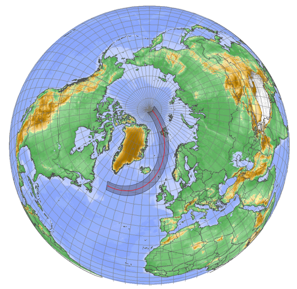
Figure 1: The track of the Moon’s shadow across the globe on March 20, 2015.
Eclipse Background
The March 20 2015 eclipse is the 61st member of the Saros 120 sequence that began on May 27, 993. Only one more total eclipse remains in the Saros cycle, 18 years and 11 days after this coming event, on March 30, 2033. Thereafter, 9 partial eclpses will fill the remainder of the cycle, ending with a 71st eclipse on July 7, 2195. The previous member of the Saros was the total eclipse of March 9, 1997, primarily over Mongolia and Siberia. The saros begins with 7 partial eclipses over southern latitudes, turning to a long sequence of annular eclipses in 1059 that continues until 1492. Thereafter, 4 hybrid eclipses introduce a small sequence of total eclipses beginning in 1582 (Figure 2). The total eclipses continue until 9 partial eclipses over northern latitudes close the cycle. Saros 120 is not an impressive cycle; its longest total was that over Mongolia, lasting 3m 10s.
Eclipse 61 begins in the western Atlantic, 650 km east of Canada’s Labrador coast and 450 km south of the southern tip of Greenland (Figure 1). It touches land at only two places: the Faroe Islands between Scotland and Iceland, and the Svalbard Archipelago (particularly, Spitsbergen Island). The Moon’s shadow lifts off of the Earth at the North Pole after a journey of 5850 km over 4h 9m. Maximum duration, northeast of the Faroe Islands, is a modest 2m 47s.
This eclipse leaves the traveller with two exotic land-based viewing options: the Faroe Islands or the Svalbard archipelago. Ships are probably not an option given the storminess of the North Atlantic in March, though the waters around Spitsbergen Island can be quiet enough if passing weather systems cooperate. Of the two possibilities, Spitsbergen Island or some other location within Svalbard offers the better cloud prospects.
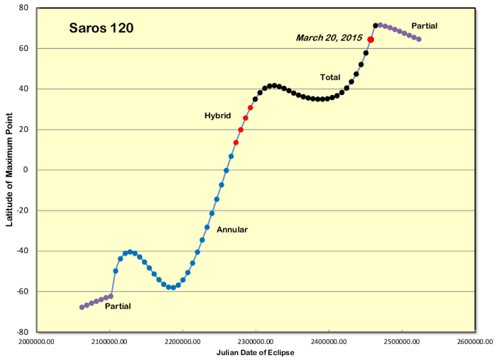
Figure 2: Graph of the progression of Saros 120 from south to north, passing through the various types of eclipses during its life cycle. The sinusoidal pattern is typical of all saros cycles. The four hybrid eclipses in the cycle mark the transition from annular to total eclipses.
Svalbard and Spitsbergen Island
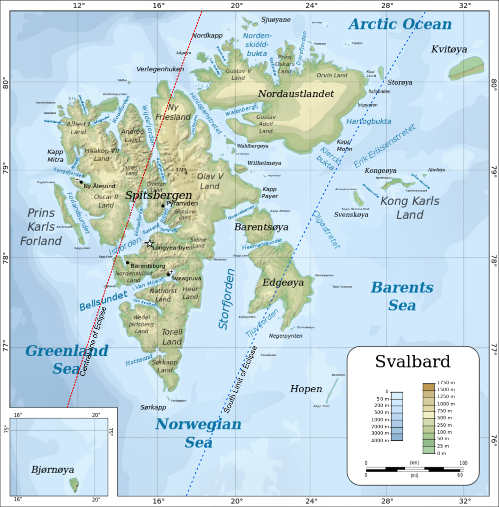
Figure 3: Track of the Eclipse shadow through the Svalbard Islands. Background map:Oona Räisänen, Wikimedia Commons.
Geographic Overview: Spitsbergen Island and Longyearbyen
Svalbard’s climate, while fundamentally that of an Arctic tundra environment, is strongly controlled by warm and cold ocean currents, a sunlight-reflecting snow cover, local topography, and a high-latitude location that limits the available amount of solar insolation. The landscape is characterized by elevated glaciers, rough mountainous terrain, steep, low-lying valleys, and dramatic fjords. Spitsbergen Island, the largest of the Svalbard group, lies at a latitude where the polar easterly winds prevail, but passing low-pressure cyclonic storms can bring a southerly flow, usually attended by heavy cloud and persistent precipitation. The temperature contrast between moderate Atlantic systems and cold Arctic air creates a large temperature gradient that gives the archipelago a highly variable weather history. Nevertheless, Svalbard is immersed in the flow of the West Spitzbergen Current, an appendage of the Gulf Stream, and so enjoys a much warmer climate than might be expected from its latitude of 78° N.
The terrain on all of the islands in the Svalbard Archipelago is steep and so the valley and fjords have a significant role in controlling wind direction, cloudiness, and precipitation. March is the month of greatest ice cover in the Arctic, and for eclipse viewing, ice cover is a good thing, blocking the moisture flux from the ocean surface so that the islands’ normal marine climate adopts a more continental flavour: temperatures are colder, precipitation lighter, and sunshine is more prevalent.
The most likely destination for eclipse chasers will be the community of Longyearbyen (Figures 5, 7) on Spitsbergen Island, which lies near the mouth of the 30-km-long SE-NW oriented Advendalen valley. The valley merges with a fjord, Adventfjorden, which in turn meets with a much larger ocean inlet, Isfjorden, which lies along a SW-NE axis (Figure 1). Under normal winter conditions, Adventfjorden is ice-covered, and Isfjorden partly so, but during the TravelQuest scouting trip in March 2012, both fjords were completely open and a ship arrived and docked to unload supplies for the community. Still, open water does not necessarily mean cloudy skies, and we were treated to mostly sunny weather during our visit.
By March 20, the Sun has returned to Longyearbyen and the day is nearly 12½ hours long, but because of the 800- to 1000-metre-high mountains to the south and southwest of the settlement, some parts of the village remain in shade throughout the day. In particular, the eclipsed Sun will be hidden over most of the community, and viewing sites must be chosen down toward the waterfront, beyond the museum and university to the north to see totality, and outside town a short distance to see the whole eclipse. More about that later.
From Longyearbyen, the main road runs southeast along the Advendalen valley, providing access to a broad, flat plain that will offer many eclipse-viewing sites. Three steep hills rise sharply on the south side of the road, tall enough to block the Sun on eclipse day from a site on the road (Figure 2), but the valleys between the hills provide openings that permit the Sun to be seen clear of the landscape. The broad 3-km-wide fields on the north side of the road provides an obstruction-free view of the Sun, and is criss-crossed with numerous snowmobile trails that provide both a solid surface for equipment and a means of access. Snowmobiles are ubiquitous in Longyearbyen and are by far the preferred means of transportation (Figure 4).
If the weather is favourable, eclipse enthusiasts might prefer to view the eclipse from the glaciers that overlook Longyearbyen. Access by snowmobile is relatively straight-forward and the view toward the eclipsed Sun will look across peaks, valleys and glaciers that dominate the landscape above the Advendallen valley. If you chose to view the eclipse from outside the settlement, it is compulsory for you or one of your party to carry a rifle and know how to use it in case of an encounter with a polar bear. The bears are protected, and shooting one will result in an investigation by the authorities. Settlement limits are marked by signs with a polar bear image, and you will be cautioned about going beyond them even a short distance – a tough regulation to follow when the aurora is dancing above the town and darker locations beckon.
Weather: The Synoptic Situation
The North Atlantic is a cloudy and stormy place, no more so than in March, being subject to three major cloud-making influences: a humid, ice-free ocean surface; a cold winter/spring atmosphere that saturates easily; and a location near the main track of low-pressure systems that leave the North American continent and venture across the North Atlantic and Barents and Greenland Seas. In the latter parts of the track, Spitsbergen and beyond, cold temperatures and sea ice (which is at a maximum in March) limit the amount of moisture in the air and weather prospects improve over those at lower latitudes.
East-coast lows moving off of North America tend to head northeastward across the North Atlantic, often dying out in a low-pressure “graveyard” between Greenland and Iceland, where they contribute to the maintenance of a semi-permanent feature known as the Icelandic Low. It’s not always the end of the line however and from Iceland, the depressions may go onward arcing around the north coast of Norway and then turning to follow the north coast of Russia (Figure 1). The dashed line in the figure marks the axis of lower pressures from a 20-year monthly average and represents the most common track of mid-latitude lows as they move into northern latitudes.
Both the Faroes and Svalbard are impacted by the passage of these migrating depressions, Svalbard less so than the Faeroes. One reason for the better weather in Svalbard is the greater distance of the islands from the average track of the lows; the other is the lower moisture content in the colder air that is found at high latitudes.
The Arctic ice pack expands during the winter months, reaching its maximum extent in March, after which it succumbs to the spring-time sunshine and begins to melt away. In years past, the ice extent was sufficient to surround Svalbard, but the gradual warming of the Earth’s climate in the past decades has eroded the extent of the pack, and it is now usual for the south and southwest shores of the archipelago to be nearly ice free in March (Figure 11). Occasionally, the winter is warm enough that even the narrow fjords that indent the south coast are ice free. Such was the case in March 2012 (Figure 8), when I visited Spitsbergen Island with the TravelQuest scouting team.
While the Faeroe Islands have their wintery days, their more southerly location embeds them in the main circulation of the Gulf Stream, and temperatures are much warmer than in Svalbard. The islands have an alpine-like climate characterized by wind, cloud, and moderate summer and winter temperatures. Because the Faeroes are more exposed to the main track of North Atlantic lows (Figure 3), the weather is highly changeable from day to day, and strong winds with heavy rain can arrive at any time of the year.
Locally, weather on both the Faroes and Svalbard are strongly influenced by the terrain, as there is a substantial up-and-down character to the landscape in both locations. The lee side of a mountain or high hill tends to have a little less cloud than upwind sites. Under the right circumstances, high ground can be used to rise above a fog or stratus layer.
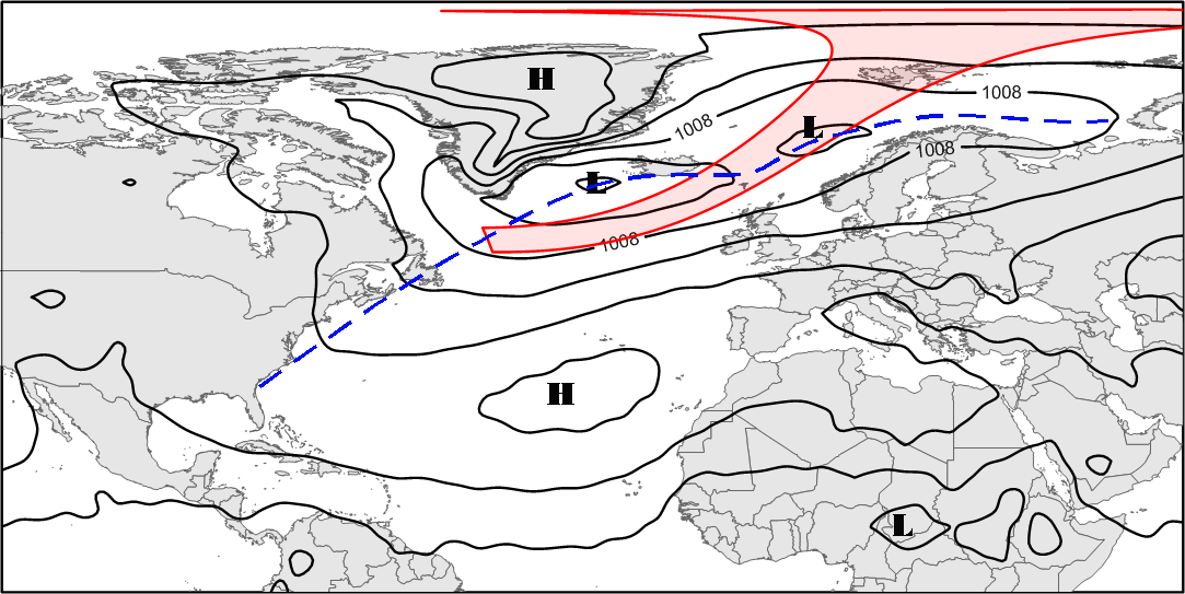
Figure 3: Mean sea level pressure over the North Atlantic in March. The dashed line marks the axis of lower pressure — the most common track of low-pressure systems moving across the North Atlantic. The distortion in the eclipse track is due to the map projection used in this display.
Geographic Overview: Spitsbergen Island and Longyearbyen
Svalbard’s climate, while fundamentally that of an Arctic tundra environment, is strongly controlled by warm and cold ocean currents, a sunlight-reflecting snow cover, local topography, and a high-latitude location that limits the available amount of solar insolation. The landscape is characterized by elevated glaciers, rough mountainous terrain, steep, low-lying valleys, and dramatic fjords. Spitsbergen Island, the largest of the Svalbard group, lies at a latitude where the polar easterly winds prevail, but passing low-pressure cyclonic storms can bring a southerly flow, usually attended by heavy cloud and persistent precipitation. The temperature contrast between moderate Atlantic systems and cold Arctic air creates a large temperature gradient that gives the archipelago a highly variable weather history. Nevertheless, Svalbard is immersed in the flow of the West Spitzbergen Current, an appendage of the Gulf Stream, and so enjoys a much warmer climate than might be expected from its latitude of 78° N.
The terrain on all of the islands in the Svalbard Archipelago is steep and so the valley and fjords have a significant role in controlling wind direction, cloudiness, and precipitation. March is the month of greatest ice cover in the Arctic, and for eclipse viewing, ice cover is a good thing, blocking the moisture flux from the ocean surface so that the islands’ normal marine climate adopts a more continental flavour: temperatures are colder, precipitation lighter, and sunshine is more prevalent.
The most likely destination for eclipse chasers will be the community of Longyearbyen (Figures 5, 7) on Spitsbergen Island, which lies near the mouth of the 30-km-long SE-NW oriented Advendalen valley. The valley merges with a fjord, Adventfjorden, which in turn meets with a much larger ocean inlet, Isfjorden, which lies along a SW-NE axis (Figure 1). Under normal winter conditions, Adventfjorden is ice-covered, and Isfjorden partly so, but during the TravelQuest scouting trip in March 2012, both fjords were completely open and a ship arrived and docked to unload supplies for the community. Still, open water does not necessarily mean cloudy skies, and we were treated to mostly sunny weather during our visit.
By March 20, the Sun has returned to Longyearbyen and the day is nearly 12½ hours long, but because of the 800- to 1000-metre-high mountains to the south and southwest of the settlement, some parts of the village remain in shade throughout the day. In particular, the eclipsed Sun will be hidden over most of the community, and viewing sites must be chosen down toward the waterfront, beyond the museum and university to the north to see totality, and outside town a short distance to see the whole eclipse. More about that later.
From Longyearbyen, the main road runs southeast along the Advendalen valley, providing access to a broad, flat plain that will offer many eclipse-viewing sites. Three steep hills rise sharply on the south side of the road, tall enough to block the Sun on eclipse day from a site on the road (Figure 2), but the valleys between the hills provide openings that permit the Sun to be seen clear of the landscape. The broad 3-km-wide fields on the north side of the road provides an obstruction-free view of the Sun, and is criss-crossed with numerous snowmobile trails that provide both a solid surface for equipment and a means of access. Snowmobiles are ubiquitous in Longyearbyen and are by far the preferred means of transportation (Figure 4).
If the weather is favourable, eclipse enthusiasts might prefer to view the eclipse from the glaciers that overlook Longyearbyen. Access by snowmobile is relatively straight-forward and the view toward the eclipsed Sun will look across peaks, valleys and glaciers that dominate the landscape above the Advendallen valley. If you chose to view the eclipse from outside the settlement, it is compulsory for you or one of your party to carry a rifle and know how to use it in case of an encounter with a polar bear. The bears are protected, and shooting one will result in an investigation by the authorities. Settlement limits are marked by signs with a polar bear image, and you will be cautioned about going beyond them even a short distance – a tough regulation to follow when the aurora is dancing above the town and darker locations beckon.
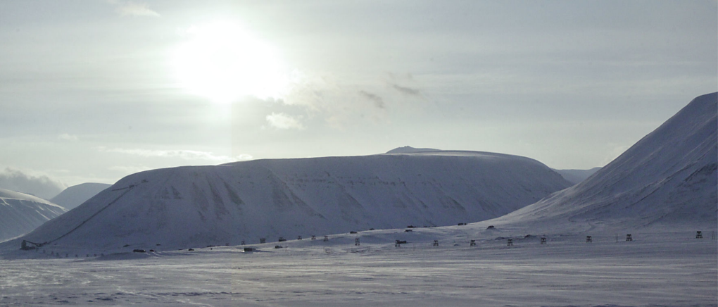
Figure 4: A view toward the south from the Adventdalen Valley east of Longyearbyen in 2012, on the date and time of the eclipse. The Sun easily clears the hills in the distance. Up close, the lower slopes are in shadow and a location must be selected so that the Sun is in the valley openings.
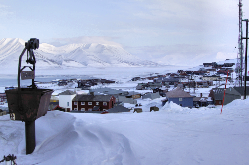
Figure 5: Longyearbyen from above. The Advendalen valley can be seen in the middle distance. Figure 7 is looking upward toward the houses on the distant hillside. Note the open water above the ore bucket on the left.
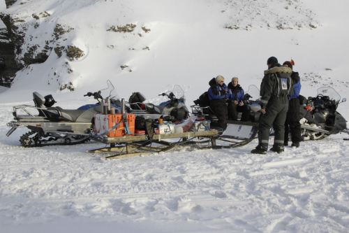
Figure 6: Snowmobiles and sleds provide a convenient and easy method of movement around the island, with access to sites that are not reachable by wheeled vehicles.
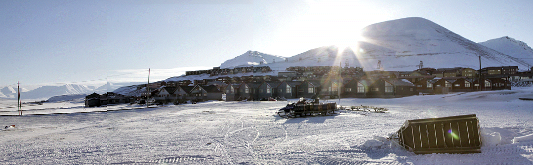
Figure 7: A view to the south of the eastern part of Longyearbyen. The Sun in this image is at its position during the eclipse, just before totality. Care must be taken to avoid being in the shadow of the mountain during the eclipse.
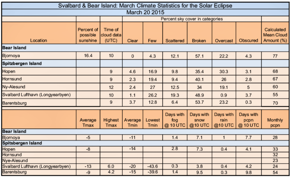
Table 1: Climate statistics for the eclipse track. Sky-cover categories: clear = no cloud; few = 1-2 eights (octas); scattered = 3-4 octas; broken = 7-8 octas; overcast = 8 octas.
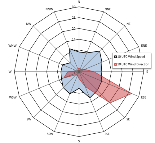
Figure 8: Wind rose for Longyearbyen Airport showing the prevailing SE and ESE winds.
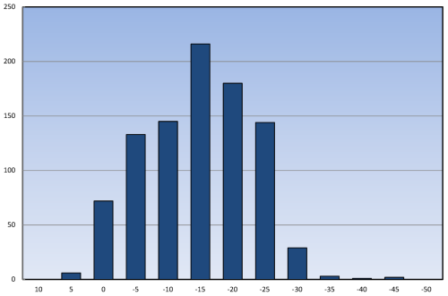
Figure 9: Histogram of daily minimum temperatures (°C) over a 30-year period at Longyearbyen airport. In each category, the x-axis value indicates the upper temperature in the 5-degree range (i.e. the -5 bar encompasses temperatures from -5 to -10).
Climate Summary for Longyearbyen
Climate statistics for Longyearbyen airport (Svalbard Lufthavn) in Table 1 show the 20-year average cloud cover for 10 UTC (mid-eclipse occurs at 10:13). Clear and overcast skies are rare; there is a modest frequency of “few” and “scattered” clouds and a high frequency of broken cloudiness. On average, this amounts to a mean cloudiness of 56 percent – a fairly promising statistic and better than the averages for Cairns in 2012. Sunshine measurements, which would reflect a more precise measurement of the probability of seeing the eclipse, are not available for the area.
Prevailing winds at the airport are strongly from the southeast and east-southeast (Figure 8), reflecting the strong control that the Adventdalen valley exhibits on the wind direction. The high latitude of the Svalbard Islands places them in the regime of the polar easterly winds, and so the above-valley wind flow comes across the mountains behind Longyearbyen and descends into the valley and into Adventfjorden. This prevailing flow is probably responsible for the low frequency of overcast skies, as a descending air flow tends to dry the atmospheric column and reduce the cloud cover. If the pack ice surrounding western Spitsbergen is thick and heavy, cloud cover is lighter and temperatures are colder.
Average temperatures are not particularly cold at Longyearbyen (Table 1), at least for this Canadian, but eclipse travellers should also be prepared for more extreme conditions. Temperatures can drop as low as -46 °C in March (or rise as high as +6), although temperatures below -35°C are very rare (Figure 7 ). In their favour, cold temperatures generally promise sunny skies. On the contrasting side, passing Arctic lows can bring blizzard conditions with wind speeds above 100 km/h, but temperatures accompanying the storms can be relatively mild.
During the TravelQuest scouting trip in March of 2012, conditions in Longyearbyen were very comfortable. Days were mostly sunny (Figure 9), though patchy, thin cloud was always present. Occasionally afternoon clouds would build on the peaks south of the settlement, drifting downwind to bring a light snowfall to the township. In most cases, movement eastward away from the peaks brought the Sun back into view. Movement is very easy around the area, as snowmobiles are available for rent, but a guide is needed for trips beyond the township and a rifle is required. It is possible to make a trip to the Russian community of Barentsburg by snowmobile, though it makes for a long day if a return trip is done all at once. Trips to the east side of the island, across the glaciers, are also possible, but will probably require an overnight stop unless you are particularly determined. Any trip outside of Longyearbyen will encounter caribou, but polar bears are less common and most likely to be seen on the east side of the island.
In 2012, during the scouting expedition, ice was all but absent in the waters of Isfjorden and Advetfjorden (Figure 8) – an unusual circumstance (Figure 9) that is becoming all to common in this era of global warming. The lack of ice cover may increase the frequency of fog and low cloud, but since the prevailing winds are offshore, the impact is limited. Temperatures are warmer whenever open water is nearby, so there is at least a small benefit from the transgressions being imposed on our planet.
Travel about Spitsbergen is a delight, whether by vehicle, snow machine, dog sled, or on foot. There are snowscapes to photograph, aurora to delight, caribou to approach, glacier caves to explore, and the traces of explorers to search out. The community, though small, has a modern look about it and a friendly people. If you want to stay, there are no immigration regulations – just arrive and settle in (on the way in and out, you will clear Norwegian customs at Tromsø). It is one of the most crime-free communities in the world. But it is expensive (though not so much as mainland Norway), and you will need to live off of your own resources.
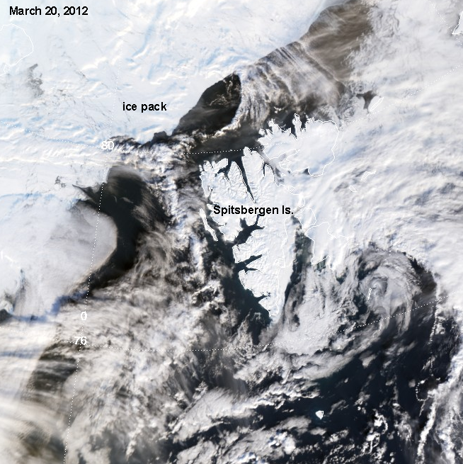
Figure 10: Aqua satellite image of Spitsbergen Island acquired 2012 March 20 during the TravelQuest scouting expedition. Note the lack of ice cover in the vicinity of the island; open water even reaches into the small fjords. Source: NASA.
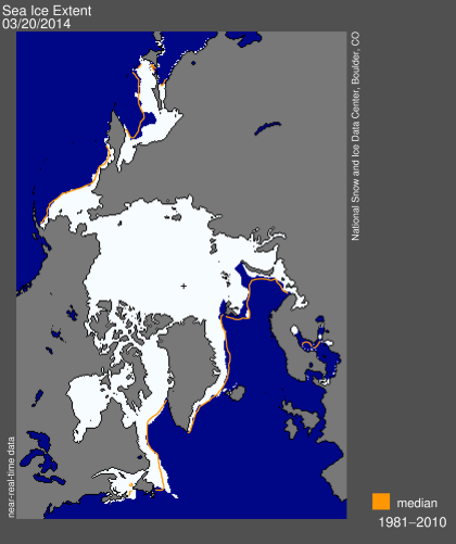
Figure 11: Sea ice extent for March 2014 and the position of the median ice edge. Note the open water along the west shore of the Svalbard Archipelago. Compare this with Figure 10. Source: NSIDC.
Viewing the Eclipse from Longyearbyen
The hills dominating the southern view from Longyearbyen impose a significant barrier to viewing the eclipse. While totality can be seen from the central parts of town near the waterfront, most of the township is enveloped in shadow from the high terrain (Figure 12) that oversees the commercial and housing sectors of Longyearbyen. The shadows move very quickly, so that those areas illuminated at total eclipse (Figure 13) cannot rely on that status for the whole of the event, from 1st to 4th contact. In figure 13, the waterfront area left of the Science Centre in the map is reliable for 1st through 3rd contact, but 4th contact will not be visible. The deep sunny indentation on the west side of the valley housing the Longyearbyen River in Figure 13 is also a poor choice for eclipse observing, as blocking shadows move across the area at critical moments.
A panoramic view of Longyearbyen from the webcam on the UCIS building (University Centre in Svalbard) is shown in Figure 14, and several animated views of the movement of the terrain shadows through the duration of the eclipse are shown in Figures 15 and 16. Overall, the best advice that can be offered to avoid terrain shadowing is to take advantage of the flat plains of the Adventdalen Valley southeast of Longyearbyen to move away from the heights. Alternatively, a site on the Longyearbreen glacier overlooking the town (Figure 12) would probably give a spectacular view of the shadow and eclipsed sun, but the area is prone to more cloudiness than the lower heights of the town. Snowmachines can reach the glacier quite easily – it seems to be a favourite hangout for local teens. Take a rifle.
Hills and mountains can be both cloud producers and cloud eaters, and often both, at the same time. When the air is unstable, cumulus clouds will form on the windward side of the 371-metre-high Sukkertoppen and 446-metre Gruvefjellet peaks that dominate the southern view from Longyearbyen. Along the Adventdalen Valley road to the southeast, four other peaks may do the same. Between the peaks, narrow but steep valleys indent the landscape from the road. While the cooling associated with the eclipse will probably erode and dissipate these clouds, eclipse sites should be selected to the north side of the road to keep the clouds low down on the south horizon, preferably facing the sun over one of the valleys. The clouds usually dissipate in the downslope flow once they leave the the peaks. The shape of the terrain along the Adventdalen Valley road is shown in figure 4.
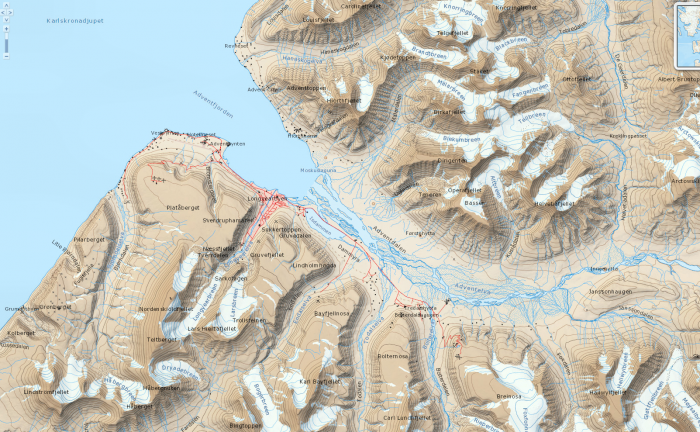
Figure 12: Topographic map of Longyearbyen and surroundings. The high terrain that surrounds Longyearbyen to the west, helps to protect the community from cloud carried on the prevailing easterly winds. The same terrain is a significant barrier to viewing the eclipse, but can be overcome by careful site selection. Click on the map for a larger version that extends farther down the Adventdalen Valley.
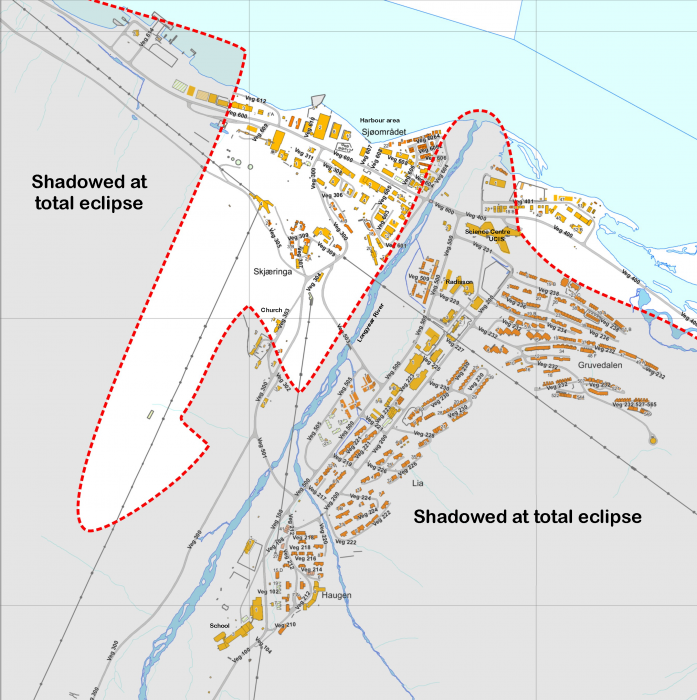
Figure 13: City map of Longyearbyen showing approximate shaded and sunny areas at the time of total eclipse. Eclipse sites selection should not rely on this map; it should be used as a guide for on-site evaluation. Click on the map for a larger version.

Figure 14: A 360° panorama of Longyearbyen captured from the web cam on top of the University Centre. This image, taken at 11:15 Svalbard time on March 19, 2014, shows the shadows cast by the peaks above the community at the approximate time of maximum eclipse (11:12 local time). Click on the image for a larger view.
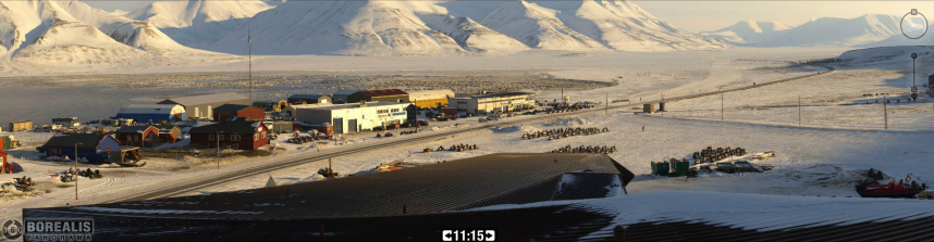
Video: Click on the image above to see a video showing the movement of terrain shadows across a northeast view of Longyearbyen. The video runs from 09:00 to 12:30 local time, slightly longer than the duration of the eclipse. The webcam that provided the images is on top of the UCIS building and is looking northeast toward the waterfront and the road along the Adventdalen Valley. The scene above shows the shadow at the time of totality. To see more of the community and to examine archive webcam images, connect to the UNIS webcam: http://longyearbyen.kystnor.no.
Viewing the Eclipse from Barentsburg
The Russian community of Barentsburg lies 37 km to the west-southwest of Longyearbyen (about 55 km overland) and only 10 km from the centreline of the ecilpse. Its proximity to the axis of the Moon’s path gives it an eclipse duration about 5 seconds longer than that at the Norwegian community. The bay in which Barentsburg is located and the surrounding mountains have a north-south orientation that puts it across the prevailing winds – a desirable orientation for controlling cloud development. Though the terrain at Barentsburg is similar to that at Longyearbyen, it is about half the height, reducing the impact of both the cloud-producing and cloud-eating characteristics of the landscape. Cloud statistics in Table 1 show that Barentsburg has a higher average cloud amount that Longyearbyen, which may be explained by the lower surrounding terrain. Barentsburg is also a little more exposed to the open sea than is Longyearbyen.
——————————————————————–
The Faroe Islands
Where Spitsbergen is a “community of the world” with a Norwegian flavour, the Faroes are the home of 50,000 independent-minded citizens occupying an island group midway between Scotland and Iceland. It’s an island landscape of rolling hills and modest mountains, deeply green when not masked by the occasional snowfall. The islands are indented with bays and fjords in a steep landscape that is dotted with sheep. Every valley that reaches the water seems to be terminated in a small community. Though under the sovereignty of Denmark, the inhabitants enjoy a measure of self-rule and speak their own language, though English is a second language to most of the Faeroese.
Despite its high, northern latitude, the islands are immersed in the North Atlantic Current, a branch of the Gulf Stream, and so enjoy a moderate climate, with temperatures varying only slightly from day to night, and usually above freezing. Because the Faroes lie in the path of passing North Atlantic lows, stormy conditions are possible at any time. Rainfall is frequent – over 260 days per year, on average. There is a standing joke on the islands that February is the dry season, “because then it can rain for only 28 or 29 days.” The terrain is very hilly, interrupted by many bays and fjords, but travel is easy thanks to a network of tunnels and bridges that join the larger islands and undercut the peaks. The ease of access around the islands may be of considerable benefit if movement is needed to avoid clouds during the eclipse.
When low-pressure systems take a more southerly track, cold Arctic air, modified by its passage over open water, will move across the islands and bring wintery weather with snow showers and a significant accumulations of snow. Such weather is more common over northern parts of the archipelago. Precipitationis heavily impacted by the terrain, with three or four times as much rain or snow falling on the heights as on protected low-level sites.
The statistics presented in Table 2 paint a grey picture, with a mean cloudiness of 75 percent and a percent-of-possible-sunshine of 24 percent at the capital, Tórshavn, for March. For a mobile eclipse seeker, these statistics can be improved by a judicious choice of observing site. The first consideration should be given to selecting a site in the lee of a line of hills so that the airflow is compelled to descend, helping to dissipate the low-level clouds. Winds tend to blow from all around the compass on the Faroes, though North, West, and Southeast are favoured (Figure 16), so the site selection must be made using the forecast wind direction in the days ahead of the eclipse; a site on the lee side of an obliging line of hills will help increase the odds of a view of the Sun.
March is not a particularly foggy month in and around the Faroes, being recorded at eclipse time (09 UTC) in the past at a frequency of 0.4 days per month at Torshavn and 0.7 days at Vagar Airport. When it does occur, in more exposed locations, the best approach is to select a site on the top of the hills. During the TravelQuest scouting expedition, we found this a very useful approach, allowing us to break into sunshine while much of the lower landscape was shrouded in fog (Figures 17). Since the islands extend a distance of 48 km from south to north, there is a good probability of at least some openings in the cloud cover unless a large-scale weather system is affecting the islands.
Past satellite images for the islands show a frequent confrontation with clouds (Figure 18), though there are occasional good-weather days and many with broken cloudiness. This is supported by the selection of satellite images in Figure 18; of the six images, one is nearly clear, two have broken cloudiness, one is sunny in the south, and two are nearly overcast. Because the Faroes lie toward the south edge of the eclipse track, there is an advantage to selecting an eclipse site as far north as possible – perhaps at Gjov, on the north coast of Eysturoy – to gain an extra 20 seconds of eclipse compared to that at the capital, Tórshavn.
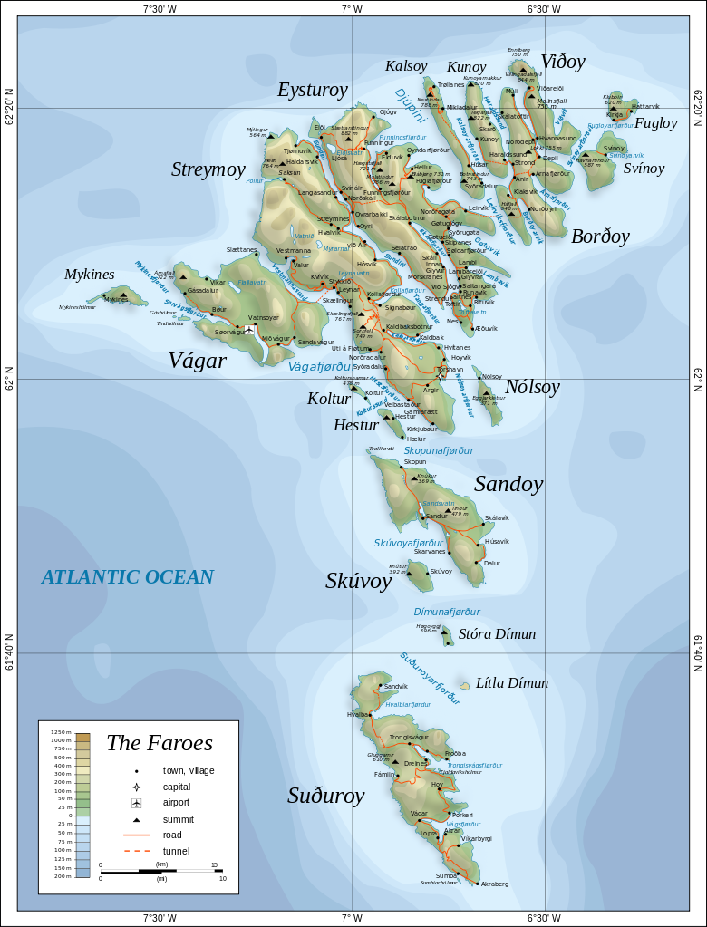
Figure 15: Map of the Faeroe Islands. The whole of the island group is embedded in the Moon’s shadow on eclipse day. Click on the map for a link to a larger version. Source: Oona Räisänen, Wikimedia Commons.
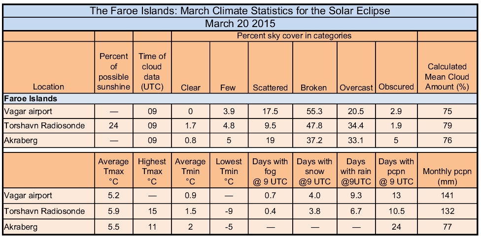
Table 2: Climate Statistics for Selected Locations on the Faroe Islands
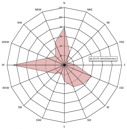
Figure 16: Wind rose showing most frequent wind directions at Vagar Airport. Vagar lies on the open west coast of the island and these winds are not representative of other sites such as Tórshavn, where the wind direction is subject to different topographic influences.
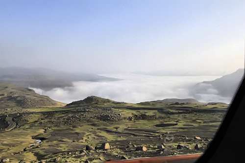
Figure17: Clear skies above the fog on the Faeroes.
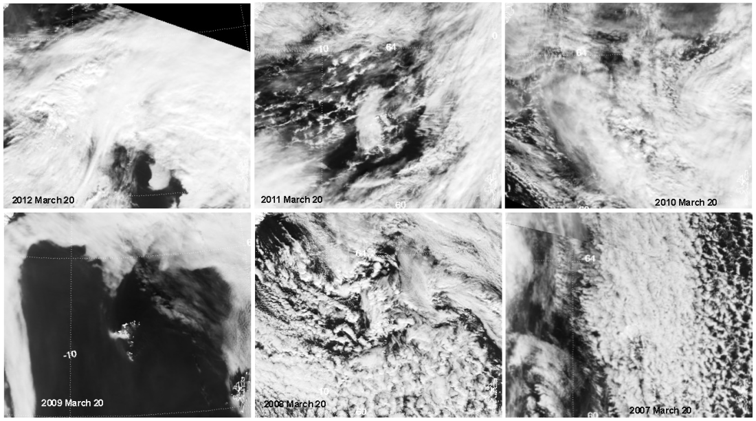
Figure 18: A montage of satellite images from 2007-2014 showing the cloud cover over the Faroe Islands on March 20. With effort, the eclipse should be possible in 2012, 2011, 2009, and possibly 2008. The years 2010 and 2007 would be more challenging, though clearer skies lie just west of the islands in 2007.
Observing Offshore from the Faroes
The Faroese are a great seagoing population, so it is not surprising that a number of options for viewing the eclipse from the open Atlantic have been offered to eclipse travellers. However, the ocean surrounding the islands is a turbulent place, frequented by storms moving off of North America or southward from the Canadian Arctic. Charts of average wave heights for March show that the islands lie withing the region containing the highest wave height contours in the North Atlantic (Figure 19). “Significant wave height” is the average of the highest one-third of wave heights in a given time. As a general rule, the largest wave that will be encountered (1 in 1000) will be about double the significant wave height.
Ship-borne observers are probably best served by selecting a location within the island archipelago waves will be severly attenuated, but such locations greatly reduce the opportunity to sail to a break in the clouds. Farther offshore, to the east, the archipelago continues to provide protection from the prevailing westherly wave and swell (Figure 19) for a considerable distance. In this east-side lee, average significant wave heights range between 2 1/2 – 3 1/2 metres but the location will be even farther from the eclipse centre line than sites on the islands themselves. Ships planning on reaching toward the maximum eclipse point north of the Faroes will experience the full impact of North Atlantic waves.
A breakdown of the wave spectrum for a site south of the Faroes can be seen in Table 3.
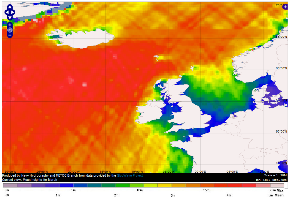
Figure 19: March mean significant wave height derived from altimeter measurements from a series of satellites: ENVISAT, ERS1, ERS2, GFO, Jason1, Jason2, and TOPEX. Wave heights average between 3.5 and 4+ metres between Iceland and Scotland. In the lee of the Faroe Islands, the prevailing westerly wind and swell are interrupted by the islands, causing average wave heights to drop below the 3-metre mark to the east of the archipelago. Data and map: USNO Hydro/Metoc and GlobalWave.
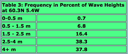
Table 3: Frequency of categorical wave heights at a location 140 km southeast of the Faroe Islands (about half-way to Scotland). More than 76% of wave heights exceed 2.5 metres.